Residents in south-east Queensland and north-east NSW are bracing for what could be the first tropical cyclone to cross the coast in decades.
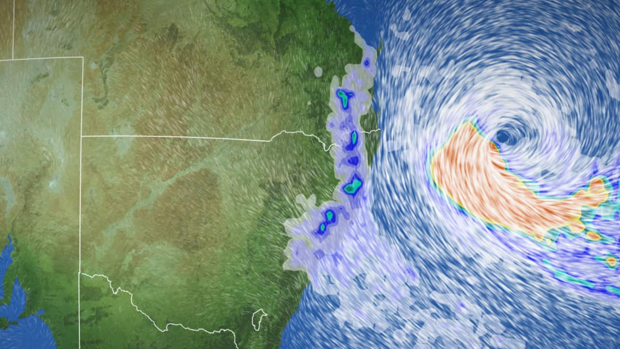
Tropical Cyclone Alfred is now 465km east of Brisbane and 430km east of the Gold Coast as a category two system, according to the latest update from the Bureau of Meteorology (BoM).
Prime Minister Anthony Albanese flew into Queensland on Tuesday to meet with local crisis support teams. The Australian Government Disaster Response Plan, which offers federal support for major disasters, has also been activated.
Meanwhile, the state’s premier as supermarket shelves were stripped bare in areas such as the Gold Coast.
The BoM expects Alfred will cross the south-east Queensland coast later this week, bringing significant wind, rain and coastal hazard impacts.
Here’s what we know — and how it could develop in the coming days.
When and where Alfred is likely to make landfall
As of Wednesday morning, a tropical cyclone warning extended from Double Island Point in Queensland down to Grafton in NSW, the BoM said.
Gale force winds are likely in these areas from later today.
Alfred is expected to move slowly in a south-easterly direction, before taking a “sharp westerly turn” and moving towards the Queensland coast.
Throughout Wednesday and Thursday, the system is expected to continue in that direction, and is likely to make a coastal crossing late on Thursday or early on Friday.
Alfred is forecast to make landfall somewhere between the Gold Coast and Sunshine Coasts on Thursday.
A volunteer marine rescue boat inspects the Seaway on the Gold Coast. Source: AAP / Jono Searle
“That means we’re likely to see the strongest impacts close to those areas, or to the south, as the heaviest rain and strongest winds generally wrap around that southern flank of a tropical cyclone,” the spokesperson said.
“Damaging to destructive wind gusts are expected, [and] heavy to locally-intense rainfall, and flooding, along with the coastal hazards we’re already seeing developing.”
These coastal impacts include damaging surf and abnormally high tides, along with dangerous offshore conditions.
Heavy rainfall is expected for parts of south-east Queensland and north-east NSW to the south of the cyclone system, with 200-400mm expected in the next few days. Isolated falls could reach 600-700mm in some areas.
Dr Liz Ritchie-Tyo, a professor of atmospheric sciences at Monash University, said “large uncertainty” remains over the actual landfall position.
Why is Alfred headed toward the coast?
Ritchie-Tyo said the movement of tropical cyclones is impacted by several factors, including wind conditions, other nearby weather systems, land surfaces — and sometimes “structural irregularities” with the cyclone itself.
“Tropical cyclones that form off the east coast of Australia generally move south and east away from the Australian coastline,” she said.
This is because they become quickly influenced by what is known as a “midlatitude flow”, which affects Australia from about 25 degrees south and generally blows from the west to the east.
“A tropical coast that moves far enough south — like Alfred — is picked up by this westerly midlatitude flow and is steered towards the east out over the Pacific Ocean,” she said.
Ritchie-Tyo said Alfred’s current south-east motion is being “heavily influenced” by what’s called a “midlatitude trough” — a low-pressure system that has extended further north than normal, “partially capturing” Alfred and causing it to change structurally.
But once the trough has passed, a “high-pressure ridge” will build and steer Alfred back towards the coast.
Tropical cyclones ‘can still track further south’
Alfred would mark the first cyclone to cross the NSW and south-east Queensland coast since 1974, when Zoe made landfall at Coolangatta. It came just weeks after Cyclone Wanda had triggered record Brisbane floods that claimed 16 lives.
There have been some near misses since, with Nancy in 1990 and Oma in 2019.
Dr Tom Mortlock, an adjunct fellow with the Climate Change Research Centre at the University of NSW, said Alfred is a reminder that tropical cyclones, while “normally contained north of the 25 degree parallel, can still track further south”.
Mortlock said while it’s uncommon, most tropical cyclone risk resides in south-east Queensland.
“This is because there is significantly more exposure — people and assets — than there is further north,” he said.
“While the probability is lower, the risk — which is probability multiplied by consequence — is much greater.”
Andrew Gissing, chief executive of the Natural Hazards Research Australia, said south-east Queensland has “developed significantly” in the years since tropical cyclones last impacted the region, “with many more people, and significant infrastructure now in the firing line”.
He said primary hazards are flooding, strong winds and coastal erosion.
“These hazards occurring in densely populated areas like Brisbane, the Sunshine Coast, the Gold Coast and northern NSW are of significant concern.”
Council workers help residents in Burleigh collect sandbags on the Gold Coast. Source: AAP / Jono Searle
What are authorities saying?
On Tuesday afternoon, Queensland Premier David Crisafulli urged residents to take Alfred “seriously”, as it makes its way towards land.
“This is a very rare event for south-east Queensland but it’s not unprecedented. I want you to take it seriously,” he told reporters.
Crisafulli said while the final path of the cyclone is unknown, preparation is key.
“The area of interest has narrowed … it is now just north of Noosa to just south of the border,” he said.
“It is a largely populated area and we are asking Queenslanders to stay on their guard.
“The preparations you put in place will make a world of difference”.
Gissing said Alfred’s possible landfall highlights that residents “must take cyclone risks seriously”.
While early preparation can reduce damage and increase safety, he said research from the centre — such as after the 2022 floods in Queensland and NSW — showed that often “people do not understand what they need to do to be fully prepared”.
Here is, before and after a cyclone warning has been issued.
— With additional reporting from Alexandra Jones and the Australian Associated Press