Update: This will be a Live Post for a few hours at least. I will post addendums at the TOP. 1.4 million homes & businesses are already without power.
8:14 PM Eastern Nowcast
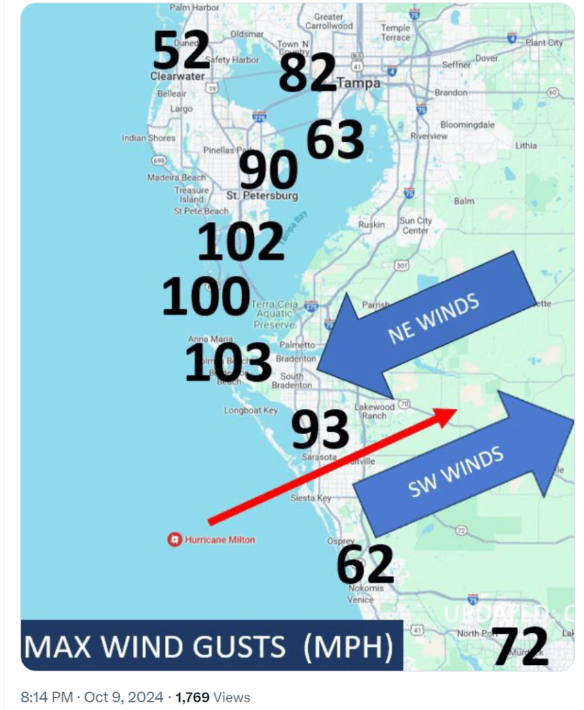
(MAX WINDS) Here are the max wind gusts recorded so far. Several wind observations over 100 mph: Skyway Fishing Pier, Egmont, & Bradenton Beach.
➡️ Significant tree & structure damage is occurring right now across (mainly western) Tampa Bay.
➡️ 1.4 million homes & businesses are already without power. It could take weeks to restore power.
Five New Videos
4 PM Eastern Nowcast
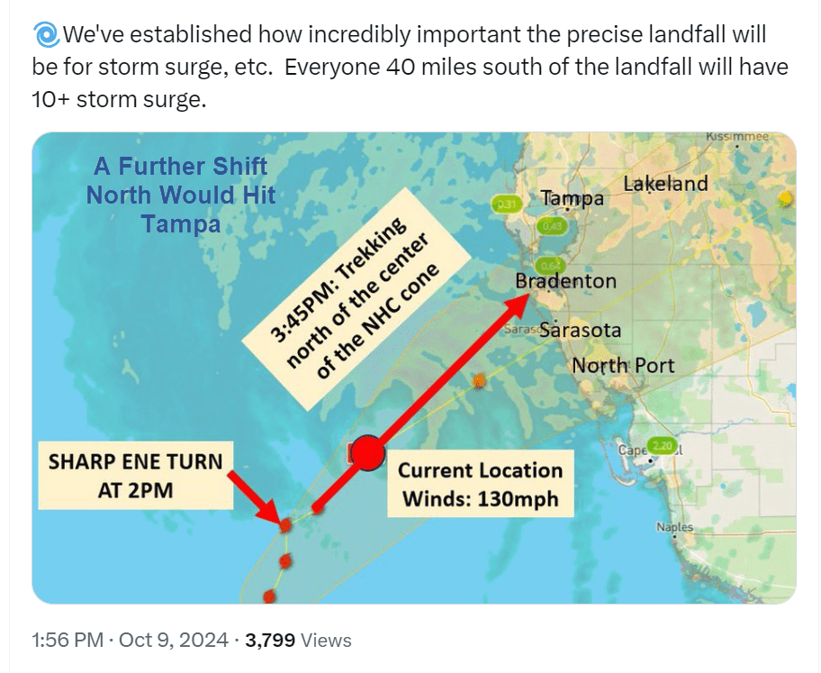
(NOWCASTING – 4PM) If #Milton stays on the current trajectory it will move into the Bradenton/Anna Maria area.
🌀There was a sharp turn toward the east around 2pm
🌀The severity of that turn has moderated. The storm is now moving with a slightly more northerly trajectory.
🌀These type of wobbles are expected & are important in the ultimate landfall location.
🌀We’ve established how incredibly important the precise landfall will be for storm surge, etc. Everyone 40 miles south of the landfall will have 10+ storm surge.
Compare the above path to the one immediately below the line.
Previous Full Post Below This Line
================================================================+
Tampa gets some welcome news as Hurricane Milton path shifts. But flooding will still be massive, and Milton has spawned an unprecedented number of tornadoes already.
Meteorologist Bryan Bennett @weatherbryan is the best one to follow on Twitter/X. I would like to embed his Tweets, but X embeds are now so unstable that I have to link to them and copy text or images.
Twelve Tornadoes
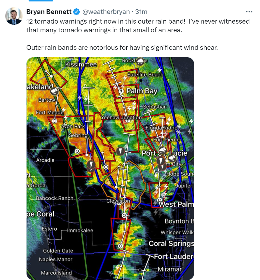
The count is actually much higher based on other reports I am reading.
Tampa Spared of Surge, but What About Rain?
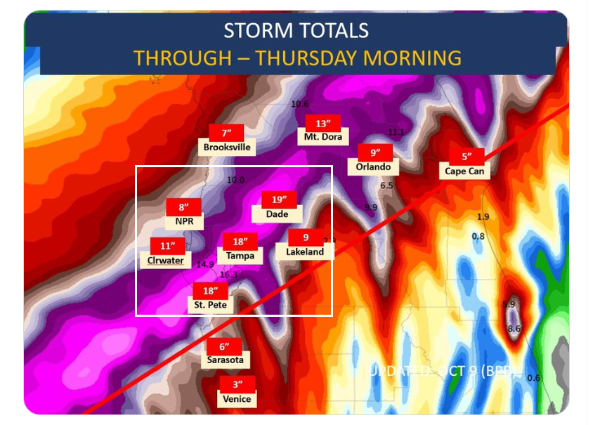
TROJAN HORSE? With focus on surge & wind, discussion of rainfall has kind of taken a back seat. But we are looking at 10-20″ of rain to fall in an area just north of the center of #Milton.
💧St. Petersburg, Tampa, & Orlando will be near or in this extremely heavy band of consistent rain.
💧WInd shear is making the storm a little lopsided, so the heaviest rain will be on the northern side of the storm.
💧The storm is slowing down which will bring a slightly longer period of time for water to accumulate.
💧Expect urban and countryside flooding overnight. Evacuate to higher ground if you are in a spot where freshwater flooding has been an issue in the past.
Likely Landfall Near Sarasota
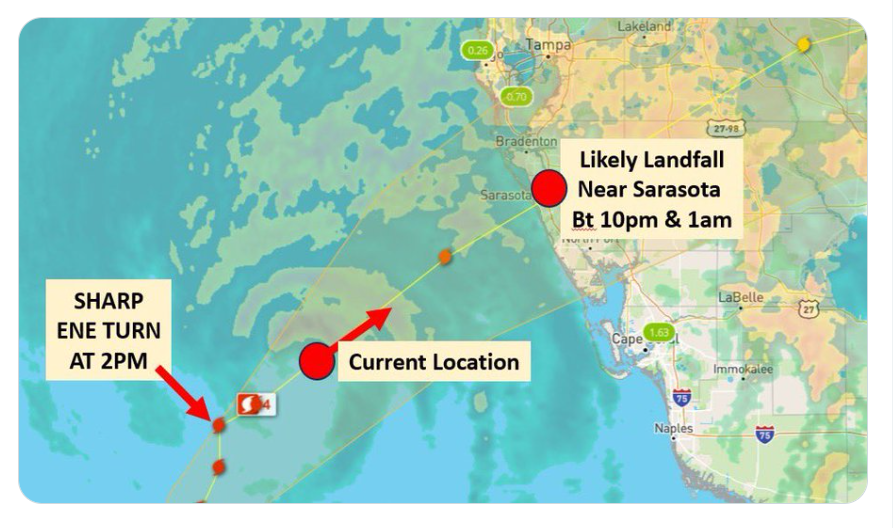
(NOWCASTING – 2:30pm) #Milton just took a SHARP turn to the east northeast.
🌀 As of 2pm, the storm was still moving north & a Pinellas landfall was starting to look more likely. Most meteorologists were about to revise the forecast & ramp up surge predictions for the Bay.
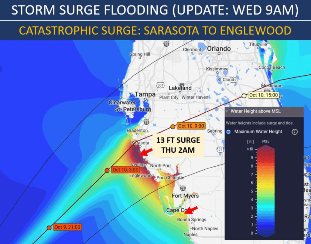
🌀 BUT, with the sharp turn at 2pm a landfall near Sarasota is remaining the most likely landfall projection. Bringing catastrophic surge to Venice, Manasota, etc.
🌀 If the storm travels on this trajectory for another hour or two it will be almost impossible to hit Pinellas.
🌀 Milton is now going to slow down, which will prolong hurricane conditions & increase accumulated rainfall.
Max Winds
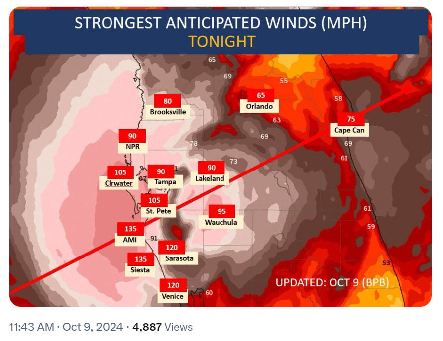
(MAX WINDS) Just about ALL of the Tampa Bay area is going to receive hurricane force winds tonight. Coastal areas near #Milton’s center will be up to 135 mph.
IMPORTANT WIND THRESHOLDS:
⚠️70-95 mph: Older mobile (pre 1994) homes destroyed, damage to shingles, vinyl siding, carports, lanais, awnings. Broken windows on higher floors of condos (windward side). Large branches & shallow rooted trees toppled. Extensive damage to power lines.
⚠️96-110 mph: Poorly constructed homes will loose roofs, high probability of broken windows, windows in high-rises often broken by flying debris, Many shallow rooted trees snapped or uprooted. Numerous roads blocked. Near total power loss. Potable water will be scarce.
⚠️111-130 mph: Old & new mobile homes will be destroyed. All unprotected windows will break, unless specialized to be hurricane proof. Siding & roof damage to well built homes. Many trees snapped or uprooted. Electricity & water will be unavailable for days to weeks.
CONCERNS:
⚠️I’ve heard several people say they are staying in their 5+story condo/apartment because they feel that they are safe from surge. Perhaps, but the windows have a high chance of breaking. It’s scary at the very least to be in a high-level windowless unit. Please evacuate condos, as well, in evacuation zones.
⚠️Soggy soil from a day of rain will lead to even more uprooted trees. Power outages are going to widespread & possibly out for weeks. Emergency vehicles will not be able to reach anyone due to blocked roads.
⚠️Debris is a large culprit behind broken windows & human/animal casualties. We have an abundance of outdoor debris in Tampa Bay due to Helene a week ago. This is almost unprecedented.
Please stay safe everyone! Follow NHC & local officials’ guidance.
Bottom Line 1:00 PM (Three Hours Ago)
BOTTOM LINE:
➡️ The hurricane is encountering some wind shear & dry air which has knocked it down to a Cat 4. It will not regain Cat 5 status.
➡️ I anticipate the hurricane to make landfall as a low end Cat 4 or a high end Cat 3 between 10pm & 4am tonight.
➡️ The model spread has reduced to only a 30 mile range from southern Pinellas to Central Sarasota Co. This will be the last model outlook that I show. I will be nowcasting until landfall.
➡️ Based on nowcasting, the storm is currently staying right on track for a landfall just north of Sarasota. But, it’s going to need to start a more easterly trajectory over the coming hours if it’s going to go south of the Bay.
➡️ A landfall just north of Sarasota appears most likely, BUT a southern Pinellas landfall can’t be completely ruled out. As previous mentioned, a Pinellas landfall will bring surge up to 13 feet into the Bay (downtown Tampa, downtown St. Pete, etc)
FORECAST:
➡️ Landfall: The strongest winds in coastal Tampa Bay will be between 7pm & 3am, with landfall occurring around midnight.
➡️ Sustained Winds: Expect sustained winds between 115 & 135 mph along unimpeded coastal Tampa Bay (aka. at the beach or Bay)
➡️ Wind Gusts: Anna Maria & Sarasota 130 mph, Siesta Key 135 mph, St. Petersburg 105 mph, Clearwater 105 mph, Tampa 90 mph, Lakeland 85 mph, Orlando 65 mph.
➡️ Rain: 10-20 inches between Pinellas County, along the I4 corridor, to Orlando.
Bottom Line:
➡️ This is a very dangerous triple threat storm with surge, wind, & rain. It’s not too late to evacuate, but the time is ticking. Please follow guidance from local officials and the NHC
Links to Twitter Posts that Won’t Embed
One year old sucked out of home by tornado in #tennessee during #helene along with the father. The entire family survived. Baby found high up in tree, alive.
Assume Climate Change is 100 Percent Manmade, OK Address My 8 Points
If you wish to politicize this as “Climate Change” and demand action, then OK.
I am game as long as you address this post: Assume Climate Change is 100 Percent Manmade, OK Address My 8 Points
Go ahead.